Summary
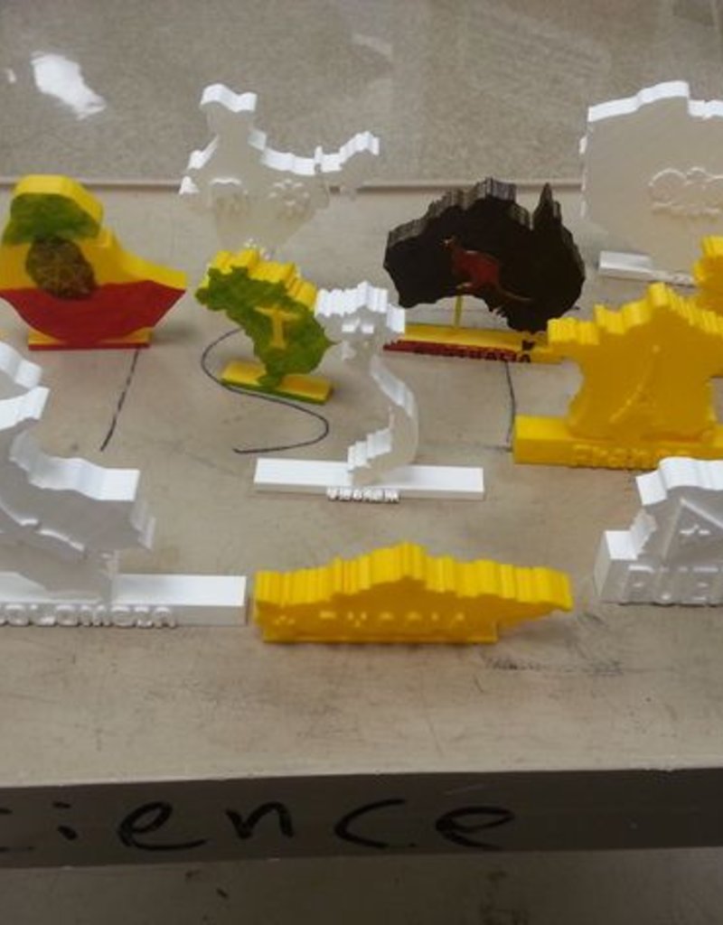
These models were created for a 7th grade cross-curricular "culture fair." See the PDF file for a full description of the project. As part of the project the kids had to make stand-up maps of their chosen country and then embellish it with the country name or something representative of the country.
The Mexico model was my example, the other models were created by the students using Tinkercad.
Standards
NGSS
Overview and Background
These models were created for a 7th grade cross-curricular "culture fair." See the PDF file for a full description of the project. As part of the project the kids had to make stand-up maps of their chosen country and then embellish it with the country name or something representative of the country.
Lesson Plan and Activity
- Use the Internet to find a map of their country
- If they find a monochrome map it can be converted into SVG using a free online image converter. Searching with terms like "clip art," "outline," "silhouette," and "black and white" will improve your chances of finding a suitable map
- If the map is not monochrome it can be inserted into a Google Drawing. Then use the line tools to trace the outline. After deleting the original map image the tracing can be downloaded as an SVG file.
- Import the map SVG file in Tinkercad, make the height (z direction) at least 10 mm
- Add a rectangular base to the map so that it will stand up when printed
- If the map is in several pieces (the islands of Japan, for example) connect the pieces to each other and the base with rectangular beams
- Embellish the map by using the Text Generator or adding shapes that are symbolic or have cultural significance. Images can be imported using the same method as was used for the map
- Double check that all parts are connected, and the height (z direction) is 10 mm or greater
- Print your model
Project: Stand Up Maps of Countries
Objective
Design a stand up map of a country
Audience
This was a 7th grade project, but could work for grades 4 - 10
Preparation
This project was part of a "culture" fair that combined social studies, art, home economics (cooking), and literature. The students had limited experience with Tinkercad.com
Steps
- Use the Internet to find a map of their country
- If they find a monochrome map it can be converted into SVG using a free online image converter. Searching with terms like "clip art," "outline," "silhouette," and "black and white" will improve your chances of finding a suitable map
- If the map is not monochrome it can be inserted into a Google Drawing. Then use the line tools to trace the outline. After deleting the original map image the tracing can be downloaded as an SVG file.
- Import the map SVG file in Tinkercad, make the height (z direction) at least 10 mm
- Add a rectangular base to the map so that it will stand up when printed
- If the map is in several pieces (the islands of Japan, for example) connect the pieces to each other and the base with rectangular beams
- Embellish the map by using the Text Generator or adding shapes that are symbolic or have cultural significance. Images can be imported using the same method as was used for the map
- Double check that all parts are connected, and the height (z direction) is 10 mm or greater
- Print your model
Results
Students were able to design and print a 3D model of their country.


")
")